Abneyville Rock Trail Guide
The Abneyville Rock Trail is a short but very remote hiking trail located in the northwestern Shawnee National Forest near Sand Ridge, with the closest city being Murphysboro.
The trail is around four miles out-and-back and has roughly 600 feet of elevation. The trails used are FSR-320 (1.5-mile out-and-back) and FSR-320A (.5-mile out-and-back), which are Forest Service Roads.
Hiking, equestrian, and mountain biking could occur here. However, many parts of the trail have suffered erosion from past 4×4 abuse and would be difficult to ride a bike or horse on, especially when wet. Hiking would be the best way to travel to this area.
This trail may become impossible to travel when river flooding occurs.
Enjoy this free guide for the Abneyville Rock Trail in the Shawnee National Forest.
Directions to Abneyville Rock Trail
Getting to the Abneyville Rock Trail is easy, but since the area is remote, it requires a lot of driving into remote areas of the Shawnee National Forest.
From Murphysboro, Illinois – take IL-149 west to S 20th Street. Turn LEFT onto S 20th Street and continue to drive as it turns into Town Creek Road for about 3 miles. Turn LEFT on Pond Ridge Road and drive less than a mile to Abneyville Road. Turn RIGHT onto Abneyville Road and drive a short distance to Pierson Road. Turn LEFT onto Pierson Road. The trail will be on your LEFT after you pass the private trail.
Parking is on the side of the road.
During wintry conditions, traveling and parking here may be difficult or impossible for most vehicles.
Pierson Road has private property on it. Please respect the private property of others.
Abneyville Rock Trail Information
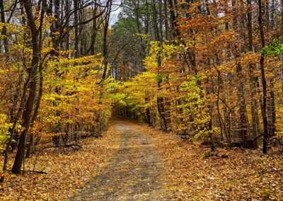
Take FSR-320 at Pierson Road to get to Abneyville Rock. The portion of the Abneyville Rock Trail follows a ridge line and starts to go downward. At some point, a trail revert was made because the trail goes away from the gated portion right before you make your way down the ridge. This was probably done by the illegal use of 4×4 vehicles trying to get around gates attempting to block their access to the roads.
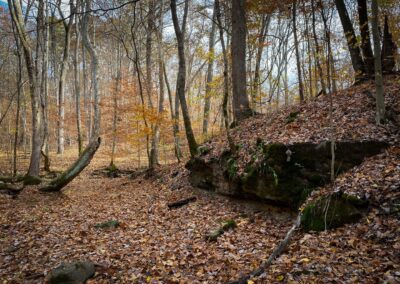
Once you make your way down, you’ll notice a few dump sites to your right. Sadly, many people in the past (and some in the present) have used the Shawnee National Forest remote sections to dump their trash. Some of the trash is very old. However, some of the trash is also brought up by river flooding.
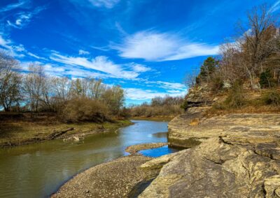
Once you’re down from the ridge, go LEFT, as the right-hand side will eventually end with private property boundaries. Going left will take you on a walk along the river until you reach a scenic creek flowing into the Big Muddy River. You can walk up the creek. It’s like seeing scenes of something out of Little Grand Canyon. It is very scenic.
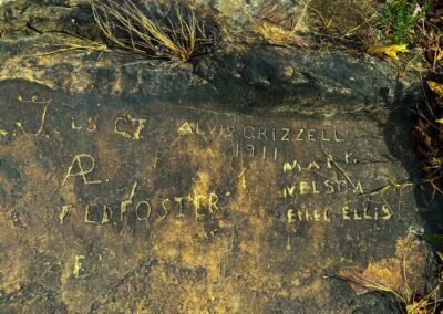
Safely cross the creek and go to the river’s edge to access Abneyville Rock. It’s just a bluff along the river. There are old carvings on the rock. There are a few nice scenic overlooks, too. You have to visit in the right conditions. If the river is flooding, you won’t be able to access most of this area. If the river is down, but it’s still wet, you might see a waterfall flowing at the creek flowing down into the river. When we went, it was during the 2022 historical drought, and it was very easy to access but very dry.
There are no other views or things to see besides what is mentioned above. FSR-320A is another short out-and-back consisting of a hill going up to a private property boundary.
Trail Safety Information
As mentioned above, parts of the Abneyville Rock Trail will be inaccessible during river flooding. This area will be underwater if the Big Muddy River is undergoing river flood conditions. Attempting to traverse through it would be hazardous to your health.
If the area is wet but not flooded, getting across the creek may present a problem. It is mainly a rock bed creek; when wet, it will be very slippery to cross. When wet, the steep hills up the creek may also pose issues and risks.
During wintry conditions, the entire area will be hazardous to hike, and the roads to the trail may be impassible to many vehicles.
Venomous snakes, including copperhead, cottonmouth, and timber rattlesnakes, occur in this area.
Poison ivy occurs in this area.
Ticks, mosquitoes, and biting flies occur in this area.
Mobile device reception will be limited in this area. Tow trucks and emergency response may take several hours to reach you. Always tell someone where you will be hiking, and try not to hike alone.
Be careful around the Abneyville Rock area itself, the bluff is high, and you could fall into the river.
Things to do around Abneyville Rock Trail
Other things to do around the Abneyville Rock Trail could make this hike and others a full day of adventure.
To your south is Little Grand Canyon, a three-mile loop trail that offers many views. To your north are miles of hiking trails, mountain bike paths, a large lake, and waterfall opportunities at Kinkaid Lake.
Lodging options include Johnson Creek Recreation Area, open from 3/15 to 12/15. There are hotel options in Murphysboro and Carbondale. Reece Ridge Cabin is close to the Abneyville Rock Trail location.
Enjoy award-winning BBQ from 17th Street BBQ in Murphysboro for dining options. Their BBQ made Murphysboro the BBQ capital of Illinois. There are other dining options around Murphysboro to choose from.
Watch the videos for this trail!
Below is a recent video that we filmed while enjoying this area.
Please Support Hiking with Shawn
Alrighty folks, I hope you have enjoyed this content. I provide it for free and it takes a while to create. If you would be so kind enough to support my efforts, you can do so by sharing this post with others, especially on social media. Be sure to subscribe to my YouTube Channel to see my latest videos, shorts and live streams. Follow me on Facebook, Instagram, Twitter and TikTok for unique content that you will only find on those pages. You might also join my Southern Illinois Hiking & Outdoor Resources Group on Facebook, too!
You can also support me by becoming a Patreon Supporter for as little as $3/month and you can cancel anytime (no contracts or catches). Patreons get access to extra features, exclusive articles, sticker packs, gifts and more. Consider buying official Hiking with Shawn Merchandise as another way to support me. I spend a lot of money on Hiking with Shawn and because of extremely high public land permit fees, I make very little money in return so everything helps.
Thanks again for checking out another one of my articles and until next time, I’ll see you on the trail!
Shawn Gossman
Founder, Hiking with Shawn
Howdy folks! My name is Shawn Gossman and I founded Hiking with Shawn. I’m an avid hiker, cyclist and outdoorsman here in the Shawnee National Forest. I was born and raised in Southern Illinois and never want to leave. Click here to learn more about Shawn Gossman

