East Peewah Loop Trail Guide
The East Peewah Loop Trail takes you on an adventure through the Indian Creek Wild Area of the Trail of Tears State Park in Southeastern Missouri.
This trail is great for day hiking, overnight backpacking, horseback riding, and more.
In this guide, I’ll explain everything you need to know about visiting the East Peewah Loop Trail at Trail of Tears State Park in Missouri.
As always, remember to put safety first when visiting these special places. Tread lightly and always practice Leave No Trace.
East Peewah Loop Area History & Information
The East Peewah Loop Trail is a breathtaking sight that is sure to brighten your day with its natural beauty.
However, this area is infamously known for the Trail of Tears, which occurred at a time when the beauty of nature and peace weren’t currently at hand.
The Trail of Tears was a historic movement of Native Americans. The movement was forced. European settlers selfishly removed Native Americans from their homes and moved them towards areas set out for reservations.
Many Native Americans died on the Trail of Tears. It was definitely a black eye to America but horrendous to Native Americans who inhabited these lands long before we did.
Today, the park’s name and points of interest serve as a powerful educational tool, teaching us about the forced migration and serving as a place for others to enjoy nature at its best.
Names like Peewah and Indian Creek were all adopted from Native American culture, reflecting the rich history and heritage of the area. Learning about the origins of these names can add a layer of cultural appreciation to your visit.
Long after the removal, much of the land was devasted for timber clearing and farming. It was a different time, and settlers were just trying to survive.
It wasn’t until the Great Depression era that parks like Trail of Tears State Park and others were established during the New Deal. Many of these locations were created by New Deal-era organizations such as the Civilian Conservation Corps, a testament to the government’s efforts to preserve natural spaces and provide recreational opportunities for its citizens during a time of economic hardship.
Trail of Tears State Park was a gift to the state by the people of Cape Girardeau County, who authorized a $150,000 bond to purchase more than 3,000 acres in 1956.
More history of the Trail of Tears State Park can be found on the Missouri Life website.
How to Get to the East Peewah Loop Trail
Getting to the East Peewah Loop Trail is straightforward and easily accessible for all visitors.
For the best directions from Saint Louis, Missouri, click this Google Maps link.
For the best directions from Carbondale, Illinois, click this Google Maps link.
For the best directions from Paducah, Kentucky, click this Google Maps link.
All the roads leading to and from the East Peewah Loop Trail are paved and can be driven by any vehicle. Biking to the trail is possible, but it involves steeper hills that require healthy and fit cyclists.
The gravel parking lot is large enough for several vehicles.
There is adequate signage and information at the parking lot so that you can learn more about the trail and the area.
Please lock your vehicle and hide any valuables before leaving for your hike.
What to do at the East Peewah Loop Trail
The East Peewah Loop Trail at Trail of Tears State Park in Southeastern Missouri offers many activities.
Day Hiking and Backpacking
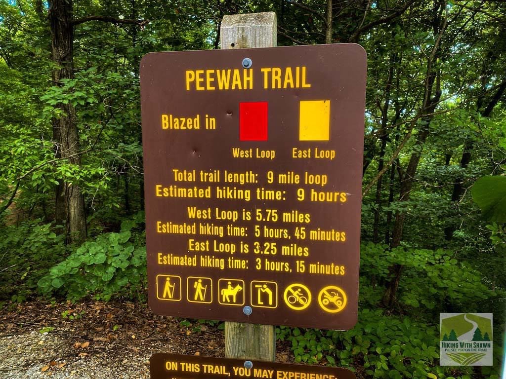
This trail is 3.9 miles long and has 685 feet of elevation. However, if you add the overlook spur, the total will be around 4.3 miles and 755 feet of elevation.
The trail is a lollipop loop and maintains itself as the Yellow Trail. There are three designated junctions along this trail: one for the overlook spur, the other for the start and end of the loop, and the other for the connection into the Red Trail loop (an additional 4 miles).
The trail is fairly hilly and can be moderately rugged at times, making it suitable for those with a moderate level of fitness. It’s important to be prepared for the physical demands of the trail, especially if you’re planning a longer hike or backpacking trip.
Backpacking is possible. Please see the Visitor Center for information and a permit if required. The white connector provides access to a camping spot. There are no improvements or water available at the camping spot.
Horseback Riding
The trail is open to horseback riding.
The Overlook Road gate will be closed daily at the assigned times. Equestrians with larger trailers may park on the grass outside the overlook gate at the entrance to the west (red) loop.
Equestrians should avoid traveling on the trail when conditions are wet and exercise caution while riding on the bluffs above the river.
Equestrian camping is not allowed.
Sightseeing
There are several things to see along this trail.
The first spur (go right) will take you to a beautiful overlook of the Mississippi River. Please use caution here, as falling from that height will likely result in death.
There are other points along the top portion of the Mississippi River side of the East Peewah Loop Trail where you can view scenic overlooks, especially in the winter.
The bottom of the trail gives you a scenic view of the swamps of the river bottoms and several passes along Indian Creek.
The hardwood forest is a lovely walk and viewing the entire time you’re using it.
Trail of Tears State Park Visitor Center
Be sure to visit the Trail of Tears State Park Visitor Center before hiking the East Peewah Loop Trail.
They can provide you with a map of the trail and interesting areas to check out along the way. It’s also a good idea to let them know you’ll be hiking the trail for your own safety. Always tell SOMEONE where you’re going to be hiking before you go.
The Visitor Center also has various educational information stations and a very cool 3D-modeled map of the State Park.
The staff at the Visitor Center are very friendly and helpful. You can tell they care about the State Park and its visitors.
You can also buy park-related merchandise from the Visitor Center, as well.
East Peewah Loop Trail Rules and Safety
The following rules and safety guidelines are recommended for following when visiting the East Peewah Loop Trail.
- The trail is open from dawn until dusk.
- Backpack camping is allowed but you must advise park staff before doing so.
- You must pack out whatever you pack in.
- Please Leave No Trace and Recreate Responsibly when hiking the trail.
- You may not harm, harass, handle, or collect any form of wildlife.
- Please stay on designated trails only.
- Open fires are not allowed.
- Equestrian camping is not allowed.
- During flooding, the bottom portion of the trail may be underwater.
- Creek crossings may require you to get your feet wet.
- This trail can be strenuous for some users
- The bottom of the trail is near a river-bottom swamp, which can be buggy during warmer months. Mosquitoes and ticks are present, so be sure to use DEET-based insect repellent when visiting this area.
- Venomous snakes occur in this area.
- Poison Ivy occurs in this area.
The best way to avoid a negative experience while visiting the East Peewah Loop Trail is to use common sense and always prioritize safety.
Lodging, Dining, and Shopping in this Area
There are many great places to eat, stay, and shop near the East Peewah Loop Trail.
The town of Fruitland has several good dining options, including Pizza Inn, TJ’s Burgers, and Las Brisas Mexican Restaurant. Cape Girardeau also has many great places to eat and shop.
As for lodging, there are a few different campgrounds located within the Trail of Tears State Park. There are basic and full hook-up sites available. There are even shower houses.
Other trails in the park, a beach, a scenic overlook, and picnic areas are also available.
Final Thoughts About the East Peewah Loop Trail
I hope you’ve enjoyed my guide for the East Peewah Loop Trail in Trail of Tears State Park in Southeastern Missouri. It’s a great trail to hike, and the park is a fun place to visit overall.
If you’ve enjoyed this article, please consider sharing it with others. You can also support me by giving me a one-time tip for writing this guide or by becoming a monthly supporter.
I also encourage you to subscribe to my free monthly newsletter for more hiking tips, resources, and local events.
And until next time, I’ll see you on the trail!
Watch the videos for this trail!
Below is a recent video that we filmed while enjoying this area.
Check out the trail gallery!
Enjoy these photos taken around this area!
East Peewah Loop Trail

Barge on the Mississippi River

Scenic River Overlook
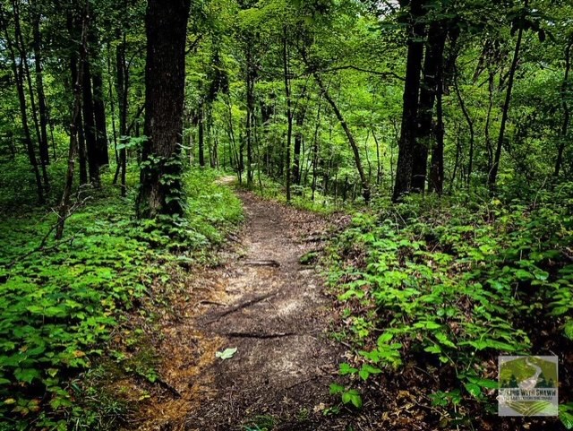
East Peewah Loop Trail Path
Please Support Hiking with Shawn
Alrighty folks, I hope you have enjoyed this content. I provide it for free and it takes a while to create. If you would be so kind enough to support my efforts, you can do so by sharing this post with others, especially on social media. Be sure to subscribe to my YouTube Channel to see my latest videos, shorts and live streams. Follow me on Facebook, Instagram, Twitter and TikTok for unique content that you will only find on those pages. You might also join my Southern Illinois Hiking & Outdoor Resources Group on Facebook, too!
You can also support me by becoming a Patreon Supporter for as little as $3/month and you can cancel anytime (no contracts or catches). Patreons get access to extra features, exclusive articles, sticker packs, gifts and more. Consider buying official Hiking with Shawn Merchandise as another way to support me. I spend a lot of money on Hiking with Shawn and because of extremely high public land permit fees, I make very little money in return so everything helps.
Thanks again for checking out another one of my articles and until next time, I’ll see you on the trail!

Shawn Gossman
Founder, Hiking with Shawn
Howdy folks! My name is Shawn Gossman and I founded Hiking with Shawn. I’m an avid hiker, cyclist and outdoorsman here in the Shawnee National Forest. I was born and raised in Southern Illinois and never want to leave. Click here to learn more about Shawn Gossman