30 Places to Hike in Southern Illinois During Hunting Season
Are you looking for places to hike in Southern Illinois during hunting season?
Firearm hunting season in Southern Illinois starts soon. During that time, avoid anywhere there might be hunters. It’s respectful and safer.
The Illinois firearm hunting seasons are on the following days:
- November 22, 23, and 24 (2024) (All Approved Firearms)
- December 5, 6, 7, and 8 (2024) (All Approved Firearms)
- December 13, 14, and 15 (2024) (Muzzleloader Only)
In this guide, I’ll show you 30 different places where you can hike in Southern Illinois during hunting season. Please note the safety tips attached to each destination.
Before You Hike in Southern Illinois During Hunting Season
Remember, safety is our top priority when hiking in Southern Illinois during hunting season. Be aware of the area, wear blaze orange for visibility, and always inform someone about your hiking plans before you leave. These measures ensure your safety and peace of mind.
As I said, the private properties attached to these areas will likely allow hunting and will likely have active hunters. Some public land attached to these areas will also allow hunting. Please use common sense when recreating in these areas.
I’ll never tell you to not hike in Southern Illinois during hunting season because that’s silly. However, I will ask that you avoid areas where hunters are for your safety and, most importantly, also to respect hunters who only get a few days a year to be able to hunt. Let’s give them a break.
30 Spots to Hike in Southern Illinois During Hunting Season
While some areas on this list prohibit hunting, it’s important to note that the surrounding properties may allow it. Therefore, exercising caution and wearing blaze orange is advised.
1 – Piney Creek Ravine
Piney Creek Ravine (Moderately Rugged) is a picturesque 2-mile lollipop loop trail with steep ravines, waterfalls, and Native American rock art, is a must-visit.
Piney Creek Ravine (Moderately Rugged) is a 2-mile lollipop loop trail with steep ravines, waterfalls, and Native American rock art.
Directions: Google Maps Link
The property around Piney Creek Ravine may have hunters present. If wet, the ravine could be hazardous and require deep creek crossings. Please use caution around high areas. The rock art is under video surveillance.
Head over to Campbell Hill for some Hillbilly’s Pizza. Ava has Brunzeez Café and Gabby’s on Main.
2 – Little Grand Canyon
Little Grand Canyon (Rugged) is a 3-mile loop trail with steep ravines, waterfalls, scenic overlooks, and views of the Big Muddy River bottoms.
Directions: Google Maps Link
The properties around Little Grand Canyon will likely have hunters. If the area is wet, hiking the canyon portion of the trail may be hazardous. Please use caution around the high areas. During heavier rain, the area in the bottoms is prone to flooding.
Mace’s Place (seasonal) is very good down the road from Little Grand Canyon. Martel’s Pizza and 17th Street BBQ in Murphysboro are also worth checking out.
3 – Pomona Natural Bridge
Pomona Natural Bridge (Easy) is a third-of-a-mile lollipop loop trail that features a large natural bridge and waterfalls when the area is wet.
Directions: Google Maps Link
Hunting may be occurring on the property around this hiking trail. Please use caution on the bridge, as falling from it would likely result in serious injuries or death. Also, use caution in areas where the rock may be wet.
Check out Carbondale for great food and a very diverse selection.
4 – Green Earth Oakland Nature Preserve
Green Earth Oakland (Easy) is a short trail through a nature preserve that features various woodland environments, wildlife viewing, and interpretive information.
Directions: Google Maps Link
Wear blaze orange when in the area to be safe in case properties around the preserve allow hunting. Please watch your step, use common sense, and Leave No Trace when hiking in this area.
Check out Carbondale for great food and a very diverse selection.
5 – Green Earth Pyles Fork Nature Preserve
Pyles Fork Nature Preserve (Easy) provides a nice 1-mile loop trail through the woods where you can view scenes of nature and wildlife.
Directions: Google Maps Link
Wear blaze orange when in the area to be safe in case properties around the preserve allow hunting. Please watch your step, use common sense, and Leave No Trace when hiking in this area.
Check out Carbondale for great food and a very diverse selection.
6 – Green Earth Brush Hill Nature Preserve
Brush Hill Nature Preserve (Easy) provides a one-mile loop through a wooded environment that was forever changed by the powerful Derecho on May 8, 2009.
Directions: Google Maps Link
Wear blaze orange when in the area to be safe in case properties around the preserve allow hunting. Please watch your step, use common sense, and Leave No Trace when hiking in this area.
Check out Carbondale for great food and a very diverse selection.
7 – Green Earth Chautauqua Bottoms Nature Preserve
Chautauqua Bottoms (Easy) provides a few miles of hiking trails (loops and out-and-backs) through diverse woodlands, grasslands, and bottomlands.
Directions: Google Maps Link
Wear blaze orange when in the area to be safe in case properties around the preserve allow hunting. Please watch your step, use common sense, and Leave No Trace when hiking in this area.
Check out Carbondale for great food and a very diverse selection.
8 – Marberry Arboretum Nature Preserve
Marberry Arboretum (Moderately Rugged) is a short hiking trail that features over 20,000 plants of over 600 species, including natives and non-natives.
Directions: Google Maps Link
Wear blaze orange when in the area to be safe in case properties around the preserve allow hunting. Please watch your step, use common sense, and Leave No Trace when hiking in this area.
Check out Carbondale for great food and a very diverse selection.
9 – Giant City Trillium Trail
Trillium Trail (Moderately Rugged) is a 1-mile loop trail that features rare native plants, large bluffs, and scenic overlooks.
Directions: Google Maps Link
While most of these trails are within the park and away from designated hunting areas, it might still be a good idea to wear blaze orange just to be safe. Please watch your steps and use common sense around the high areas.
Check out Giant City Lodge and the Village of Makanda for dining and snack options.
10 – Giant City Nature Trail
Nature Trail (Moderately Rugged) is a 1-mile lollipop loop trail that features natural shelters, bluffs, and a street-like area of rocks of carvings as old as the Civil War days.
Directions: Google Maps Link
While most of these trails are within the park and away from designated hunting areas, it might still be a good idea to wear blaze orange just to be safe. Please watch your steps and use common sense around the high areas.
Check out Giant City Lodge and the Village of Makanda for dining and snack options.
11 – Giant City Devil’s Standtable Trail
Devil’s Standtable Trail (Moderately Rugged) is a short loop hiking trail that features amazing natural shelters, waterfalls (when wet), tall bluffs, and a balancing rock that looks like a table standing.
Directions: Google Maps Link
While most of these trails are within the park and away from designated hunting areas, it might still be a good idea to wear blaze orange just to be safe. Please watch your steps and use common sense around the high areas.
Check out Giant City Lodge and the Village of Makanda for dining and snack options.
12 – Giant City Stonefort Trail
Stonefort Trail (Moderately Rugged) is a less-than-mile out-and-back trail that features waterfalls (when wet), tall bluffs, scenic overlooks, and a reconstructed ancient Native American Stonefort.
Directions: Google Maps Link
While most of these trails are within the park and away from designated hunting areas, it might still be a good idea to wear blaze orange just to be safe. Please watch your steps and use common sense around the high areas.
Check out Giant City Lodge and the Village of Makanda for dining and snack options.
13 – Giant City Post Oak Trail
Post Oak Trail (Easy) is a short ADA-compliant hiking trail that features forest bathing and scenic overlooks of the Devil’s Backbone area.
Directions: Google Maps Link
While most of these trails are within the park and away from designated hunting areas, it might still be a good idea to wear blaze orange just to be safe. Please watch your steps and use common sense around the high areas.
Check out Giant City Lodge and the Village of Makanda for dining and snack options.
14 – Giant City Arrowood Interpretive Trail
Arrowood Trail (Easy) is a short lollipop loop hiking trail with interpretive signage that shows hikers what sort of forest features they are seeing as they hike the trail.
Directions: Google Maps Link
While most of these trails are within the park and away from designated hunting areas, it might still be a good idea to wear blaze orange just to be safe. Please watch your steps and use common sense around the high areas.
Check out Giant City Lodge and the Village of Makanda for dining and snack options.
15 – Ferne Clyffe Blackjack Oak Trail
Blackjack Oak (Moderately Rugged) is a short out-and-back trail featuring multiple scenic overlooks, amazing bluffs (designated for climbing), natural shelters, and a diverse forest.
Directions: Google Maps Link
While most of these trails are within the park and away from designated hunting areas, it might still be a good idea to wear blaze orange just to be safe. Please watch your steps and use common sense around the high areas.
Check out Whiffle Boy’s Pizza in Goreville for some great pizza and sandwiches.
16 – Ferne Clyffe Hawk’s Cave Trail
Hawk’s Cave (Easy) is a one-mile lollipop loop trail that features one of the largest natural cave shelters in the Southern Illinois region, located on public land.
Directions: Google Maps Link
While most of these trails are within the park and away from designated hunting areas, it might still be a good idea to wear blaze orange just to be safe. Please watch your step and use common sense around the high areas.
Check out Whiffle Boy’s Pizza in Goreville for some great pizza and sandwiches.
17 – Ferne Clyffe Rebman Trail
Rebman Trail (Moderately Rugged) features a 1-mile lollipop loop hiking experience with waterfalls (when wet), tall bluffs that you can legally climb, and scenic views.
Directions: Google Maps Link
While most of these trails are within the park and away from designated hunting areas, it might still be a good idea to wear blaze orange just to be safe. Please watch your step and use common sense around the high areas.
Check out Whiffle Boy’s Pizza in Goreville for some great pizza and sandwiches.
18 – Ferne Clyffe Boy Scout Trail
Boy Scout Trail (Moderately Rugged) is a short out-and-back hike on the old roadway into the park from Goreville. When wet, it features a waterfall but also a steep climb, making it great for exercise.
Directions: Google Maps Link
While most of these trails are within the park and away from designated hunting areas, it might still be a good idea to wear blaze orange just to be safe. Please watch your step and use common sense around the high areas.
Check out Whiffle Boy’s Pizza in Goreville for some great pizza and sandwiches.
19 – Big Rocky Hollow Trail
Big Rocky Hollow (Easy) is a short out-and-back hiking trail that features a tall waterfall (rainfall dependent) at the end of the trail.
Directions: Google Maps Link
While most of these trails are within the park and away from designated hunting areas, it might still be a good idea to wear blaze orange just to be safe. Please watch your step and use common sense around the high areas.
Check out Whiffle Boy’s Pizza in Goreville for some great pizza and sandwiches.
20 – Ferne Clyffe Round Bluff Trail
Round Bluff Nature Preserve (Moderately Rugged) is a 1-mile loop trail through the only nature preserve in Ferne Clyffe State Park.
Directions: Google Maps Link
This particular area sits next to private property, so hunters will likely be present. Please wear blaze orange and stay on the designated trail at all times. Please watch your step and use common sense around the high areas.
Check out Whiffle Boy’s Pizza in Goreville for some great pizza and sandwiches.
21 – Heron Pond Preserve
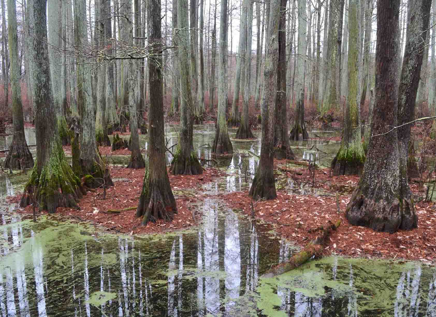
Heron Pond Preserve (Easy) involves hiking a few miles through a swamp with a boardwalk, large cypress trees, and occasional swamp wildlife.
Directions: Google Maps Link
This particular area sits next to private property, so hunters will likely be present. Please wear blaze orange and stay on the designated trail at all times. Please watch your step and use common sense around the high areas.
Check out the City of Vienna for great dining and snack options.
22 – Tunnel Hill State Trail
Tunnel Hill State Trail (Easy) is a 55-mile point-to-point rail trail where cyclists, runners, and hikers can enjoy multiple trestles and a 500+ foot tunnel that you can go through.
Directions: Google Maps Link
This particular area sits next to private property, so hunters will likely be present. Please wear blaze orange and stay on the designated trail at all times. Please watch your step and use common sense around the high areas.
Check out the City of Vienna for great dining and snack options.
23 – Lake Glendale Lake Trail
Lake Glendale (Easy) is a 3-mile loop trail around the lake, featuring scenic views of the lake and a diverse Shawnee National Forest.
Directions: Google Maps Link
This particular area sits next to public land where hunting is allowed, so hunters will likely be present. Please wear blaze orange and stay on the designated trail at all times. Please watch your step and use common sense around the high areas.
Check out the Historical Main Street of Golconda for some excellent dining options. Be sure to stop by the Chocolate Factory for some sweet treats.
24 – Millstone Bluff Trail
Millstone Bluff (Easy) is a one-mile lollipop loop trail that features a historical past, from an ancient Native American village to the creation of millstones.
Directions: Google Maps Link
This particular area sits next to private property, so hunters will likely be present. Please wear blaze orange and stay on the designated trail at all times. Please watch your step and use common sense around the high areas.
Check out Shotgun Eddy’s and Shawnee Mart in Eddyville for great good and snacks.
25 – Bell Smith Springs White Trail
White Trail (Moderately Rugged) features a short out-and-back hike to popular spots at Bell Smith Springs, including the Jumping Rocks, the spring, and Devil’s Backbone.
Directions: Google Maps Link
This particular area sits next to private property, so hunters will likely be present. Please wear blaze orange and stay on the designated trail at all times. Please watch your step and use common sense around the high areas.
Check out Shotgun Eddy’s and Shawnee Mart in Eddyville for great good and snacks.
26 – Bell Smith Springs Yellow Trail
Yellow Trail (Moderately Rugged) is a short out-and-back trail that leads you to the largest natural arch in the state of Illinois.
Directions: Google Maps Link
This particular area sits next to private property, so hunters will likely be present. Please wear blaze orange and stay on the designated trail at all times. Please watch your step and use common sense around the high areas.
Check out Shotgun Eddy’s and Shawnee Mart in Eddyville for great good and snacks.
27 – Garden of the Gods Observation Trail
Garden of the Gods Observation Trail (Easy) is a loop trail less than a mile in length that features some of the best rock formations in Southern Illinois including Camel Rock and Devil’s Smokestack.
Directions: Google Maps Link
This particular area sits next to a wilderness area where hunting is allowed. Please wear blaze orange and stay on the designated trail at all times. Please watch your step and use common sense around the high areas. People have died here (adults and children) as a result of falling from the rocks. Use extreme caution and watch your pets and children at all times.
For great dining and snack options, check out Garden of the Gods Outpost, Harbison’s Country Market, and Harrisburg Restaurants.
28 – Rim Rock National Recreation Trail
Rim Rock (Moderately Rugged) is a short trail system that features a Native American Stonefort, cave shelters, street-like bluffs, and access to Pounds Hollow Beach (swimming is closed for the season).
Directions: Google Maps Link
This particular area sits next to a wilderness area where hunting is allowed. Please wear blaze orange and stay on the designated trail at all times. Please watch your step and use common sense around the high areas.
For great dining and snack options, check out Garden of the Gods Outpost, Harbison’s Country Market, and Harrisburg Restaurants.
29 – Iron Furnace Picnic Area
Iron Furnace (Easy) is a sightseeing location where you can see a reconstructed iron furnace and enjoy a picnic area.
Directions: Google Maps Link
This particular area sits next to a wilderness area where hunting is allowed. Please wear blaze orange and stay on the designated trail at all times. Please watch your step and use common sense around the high areas.
For great dining and snack options, check out Garden of the Gods Outpost, Harbison’s Country Market, and Harrisburg Restaurants.
30 – Cave-in-Rock Trail
Cave-in-Rock (Moderately Rugged) features a short out-and-back trail that leads to a large, deep natural cave shelter next to the Ohio River. This shelter was once used by murderous river pirates and has even been featured in a movie.
Directions: Google Maps Link
Please be careful near the river. If the river is flooding, this area will be inaccessible. Please watch your step and use common sense around the high areas.
Check out Kaylor’s Lodge within Cave-in-Rock State Park for some excellent dining.
Final Thoughts
Thank you for taking the time to read my guide on 30 great spots to hike in Southern Illinois during hunting season. The hiking trails above should keep you busy all year long.
Where’s your favorite place to hike in Southern Illinois during hunting season? Comment below and tell me what your go-to spots are.
If you like hiking and backpacking, join my free online community, The Hiking Forum, to discuss hiking and backpacking all over the world with other hikers. Membership is free, and there are no ads.
Please share this article with others who would love to know where to hike during hunting season. You can also support me by buying me a pizza or becoming a Patreon supporter.
Subscribe to my free newsletter for monthly hiking tips, resources, and upcoming local events.
And until next time, I’ll see you on the trail.
Please Support Hiking with Shawn
Alrighty folks, I hope you have enjoyed this content. I provide it for free and it takes a while to create. If you would be so kind enough to support my efforts, you can do so by sharing this post with others, especially on social media. Be sure to subscribe to my YouTube Channel to see my latest videos, shorts and live streams. Follow me on Facebook, Instagram, Twitter and TikTok for unique content that you will only find on those pages. You might also join my Southern Illinois Hiking & Outdoor Resources Group on Facebook, too!
You can also support me by becoming a Patreon Supporter for as little as $3/month and you can cancel anytime (no contracts or catches). Patreons get access to extra features, exclusive articles, sticker packs, gifts and more. Consider buying official Hiking with Shawn Merchandise as another way to support me. I spend a lot of money on Hiking with Shawn and because of extremely high public land permit fees, I make very little money in return so everything helps.
Thanks again for checking out another one of my articles and until next time, I’ll see you on the trail!
Shawn Gossman
Founder, Hiking with Shawn
Howdy folks! My name is Shawn Gossman and I founded Hiking with Shawn. I’m an avid hiker, cyclist and outdoorsman here in the Shawnee National Forest. I was born and raised in Southern Illinois and never want to leave. Click here to learn more about Shawn Gossman

