Hiking with Shawn’s Trail Guide Series:
Piney Creek Ravine
Piney Creek Ravine, while well known, is a sort of hidden gem in southern Illinois. It is located on the west side of the state near Ava, Illinois and provides a wonderful hiking opportunity as well as an historical educational opportunity. Piney Creek Ravine has the largest amount of Native American Rock Art in the State of Illinois. Aside from the rock art, the hiking experience is a fun experience for the whole family and if you go when wet, there are plenty of opportunities to see some amazing waterfalls.
If you look at the area on Google, from a bird’s eye view, you will truly understand how much of a gem it really is. This small portion of forest is surrounded by farmland and Amish country. It almost seems like it shouldn’t be here and that is what makes it a really special gem of southern Illinois.
Do note that this area is of high importance to historical preservation. Surveillance cameras are in use to protect Native American culture and the area is frequently patrolled by local law enforcement, conservation police and nearby locals who will protect the area like it is their own property. Vandalism of any kind done here will be met with swift punishment, as it should be!
Directions and Stuff!
If driving from Marion, Illinois – see this Google Map for directions to Piney Creek Ravine. You can change the starting point to where you want to start from. Do not that other sources of directions different from the map link I provided have ended with me down a private lane in the middle of nowhere.
All roads that lead to the parking lot are either paved or gravel but are all in good conditions that most any type of car should be able to drive on for all conditions. However, it is the country and during wintry precipitation, there may not be adequate snow/ice removal services. This is considered Amish country and there are no businesses around the area. Cell phone service is not always completely reliable in this area.
Please only park in the designated parking lot for Piney Creek Ravine. Parking on the road can hinder farming operations of the people who have to live out there. Your vehicle may be towed away at your own expense if you park outside of the designated parking lot. Please Recreate Responsibly when enjoying this beautiful gem of southern Illinois.
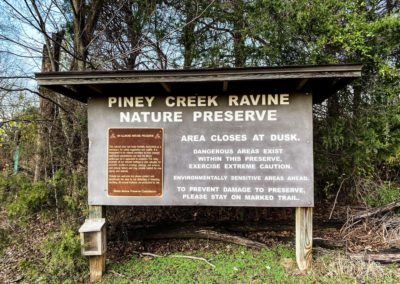
Once you have parked your vehicle, the trail is to the left of the sign. There is a gate across it. Go around the gate and follow the trail. When wet, there is a spot that has a large puddle across the trail. If you’re not wearing proper footwear, you will probably get wet. Once you reach the start of the woods, the trail is to your right. The trail to your left is old and just stops after about 50 feet or so. This is a loop trail and is best done clockwise. If the creek is too high to cross when going clockwise, you could go counterclockwise to see everything and come back that way but it will make the hike longer.
To ensure that you do not get lost, you should stay on the designated trail at all times. The trail is used enough to know where it is but there is some signage present in the more difficult leaf covered areas. Dangerous conditions exist at this site, getting off trail could put you into a hazardous and even deadly situation. Please hike this area at your own risk and never hike alone. If the area is wet, the conditions will be even more hazardous – please always put safety first!
This site is managed by the Illinois Department of Natural Resources not the US Forest Service. Click here to see the area link and information page.
What You’ll See!
The Piney Creek Ravine loop trail is a little over 2 miles and considered moderately rugged. This is due to some rolling hills, rocky conditions, creek crossings and slippery surfaces along the trail. Total elevation will be around 250-300 feet at most so it isn’t super hilly as long as you stay on the designated trail. There are some switchbacks present to make the hike easier in the more hilly sections of the trail.
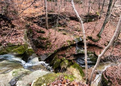
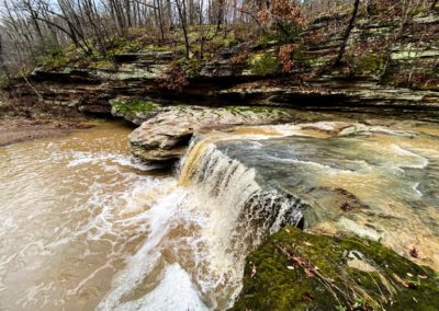
Starting clockwise at the start of the loop, you’ll make your way down to the creek. There will be areas with waterfalls to your left before the creek if it is wet. Please use caution when around those areas, people have fallen there. There is a neat area there but rather steep to get to that will have three waterfalls flowing all around one and another. It is very neat to see! Once you get to main creek, cross it if you can and continue a very short hike (within feet) to the rock art wall.
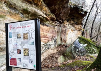
Note the cameras that are recording (LIVE FEED) the rock art wall. These were installed due to vandalism. Check out the signage to see if you can spot Native American and early settler rock art on the wall.
The Illinois Department of Natural Resources says this about Piney Creek Ravine:
“Piney Creek Ravine contains the largest body of prehistoric rock art in Illinois. Almost 200 designs believed to date to the Late Woodland (A.D. 500-1000) and Mississippian (A.D. 1000-1550) periods occur within the ravine. Prehistoric rock art was created by either pecking and grinding (petroglyphs) or painting (pictographs) designs on rock surfaces. Petroglyphs were created by using a small hard rock as a hammer to peck a design into a softer rock, such as sandstone. Paintings were created by grinding minerals, such as limestone, into a yellow or red powder, which when mixed with animal fat adheres to rock surfaces.”
What can you see on the rock art wall?
Continue hiking the trail to enjoy beautiful views of the forest and creeks around you. You’ll also enjoy a lot of awesome bluffage, natural shelters and interesting formations. You can also see dig sites from long ago. Do note that digging and collecting anywhere in this area is a criminal offense! Don’t do it!
Continue hiking to get into the hilly portion of the area. After you make it up, you’ll start to notice pine trees everywhere. These are short-leaf (short-needle) pine trees and they are the only native pine trees in southern Illinois. These trees are at Piney Creek and Pine Hills. All other pine trees in southern Illinois are not native and were simply planted to help control erosion.
After making it through the pine tree jungle, you’ll make your way down into another waterfall section of the area. Continue past it and take the side trail that follows the creek to see an even better waterfall.
And continue on to reach the end of the loop. In the end, this area is extremely interesting and worth visiting. While the hike is short, there is a lot to see!
Tips for the Trail!
- Use caution when the area is wet – dangerous conditions are present!
- Venomous copperheads and poison ivy plants are present.
- There is no trash service here – pack out what you pack in.
- Bring plenty to drink and a snack. Wear proper footwear and watch your step!
- Do not collect, dig, harvest, carve or destroy anything in this area.
- Stay on the designated trail to avoid hazardous conditions.
- The creeks will be impassable if flooding has occurred.
Watch the videos for this trail!
Below is a recent video that we filmed while enjoying this area.
One last thing!
Filming the videos, taking the photos, editing everything and writing this article takes time and it’s all provided for free. Consider making a small monthly contribution to Hiking with Shawn by becoming an official Patreon supporter on Hiking with Shawn! You can also support us by purchasing official merch from the Hiking with Shawn online store. Lastly, please share this article and our videos and follow us on YouTube, Facebook, Twitter, Instagram and Tumbler for more free guides, videos, photos, contests and more!
Thanks for checking out this guide and please share it with others if you’d like to see more of them made!

Shawn J. Gossman
Host
Shawn is the founder and host of the YouTube Channel, Hiking with Shawn as well as Hiking with Shawn LLC. Shawn hikes, backpacks and visits various forested areas in the Shawnee National Forest, local state parks and other areas promoting outdoor recreational activities to obtain video to show to locals and non-locals alike. Please support Shawn’s efforts by sharing this post and leaving a comment below.

Thank you so much for the great description of piney creek. My husband and I drove out there yesterday and I wish I had seen your site earlier, we didn’t do enough homework before we went and didn’t actually go on the trail because we weren’t sure of what we were getting into. Thanks again.
Shirley
Do go back sometime, it’s a blast!
Shawn,
What is in your opinion the best month to visit Piney Creek Ravine?
Mick
Honestly, Late-Jan to Early-Feb when all the leaves are off the trees. Go when it’s cloudy to see the rock art best.