5 Must Visit
Scenic Creeks
around the
Shawnee National Forest
Scenic creeks make for great photography moments. Whether you’re a professional using a high-end DSLR camera or an amateur using your smart phone camera, a good scenic creek provides an excellent opportunity to show off nature. Luckily, there are no short supply of scenic creeks within the Shawnee National Forest and southern Illinois State Parks. In this article, we are going to look at 5 Must Visit Scenic Creeks in and around the Shawnee National Forest that anyone may go access. If you have enjoyed this article after reading it, please share it to support my efforts. You can also become a Patreon Supporter to get access to even more premium articles if you want to.
#1 – Cedar Creek
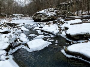
Cedar Creek after a few days of snowfall.
Cedar Creek (37°29’46.4″N 88°45’31.9″W) located near Simpson is nestled into the Gum Springs area of the Shawnee National Forest. Throughout this area, often called Cedar Creek Wonders, the creek feeds countless waterfalls and goes next to some interesting rock formation. The short 1-mile out and back Buffalo Rock trail parallels the creek giving photographers ample opportunity to take various photos of different scenes and positions. This creek is nice to see all year, but I have found it to be its prettiest during fall colors and wintertime when snow and ice is on the ground. The coordinates listed on this creek will take you to the Gum Springs Trailhead. More Information
#2 – Stonefort Road Creek
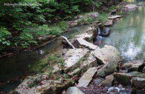
Drury Creek with a waterfall.
This is likely a branch of Drury Creek (37°36’34.6″N 89°11’39.6″W) that runs parallel for most part along Stonefort Road at Giant City State Park in Makanda. The coordinates above show the southern portion of where the creek gets larger. However, on this road, there are quite a few pull-over and parking lot spots to be able to access the creek. I used to road bike a lot in Giant City State Park and I was always stopping to take photos of the creek. There are creek waterfalls and cascades, more natural rocky areas and even parts that you can see remnants of the Civilian Conservation Corps (CCC) work. It truly is a remarkable creek for photography. I highly suggest you go after a good few days of rain during the wetter seasons for the best results. More Information
#3 – West Rice Hollow Creek
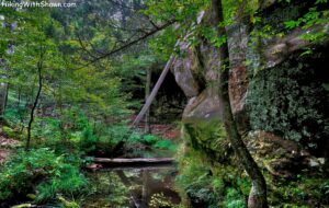
Rice Hollow Creek during the summer.
This is likely a branch of Little Eagle Creek (37°37’12.2″N 88°21’00.7″W) that we hikers and equestrians called West Rice Hollow. The coordinates will take you to where the creek is. The area gets extremely grown up during warmer months, so I recommend late fall, winter, and early spring for the best visiting times. Try to go when it has been wet for a while too in order to really see the creek as beautiful as it can be. This area isn’t for the faint of heart, it is a very rugged and challenging area especially when it is wet. Check out the Multi-Day Bundle for the Avenza App for accessing this area. More Information
#4 – Hutchins Creek
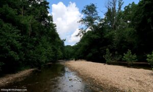
Hutchins Creek
Hutchins Creek (37°34’19.5″N 89°23’41.7″W) has to be my favorite creek in southern Illinois. This is because it is said to get its water from natural springs, and it is the closest creek we have that looks like something out of the Missouri Ozarks. This is because the Ozark Range goes slightly into southern Illinois and Hutchins Creek is a part of that. It is why you don’t see a creek like it anywhere else in the region aside from that particular area of the more southern portion of the state. My coordinates above require you to trek through the wilderness on a longer and rugged hike starting from Godwin West or Godwin East. I recommend going during late fall or early winter. There are so many photo opportunities along this creek and accessing it in the wilderness area will give way better shots in my opinion. More Information
#5 – Hills Branch Creek
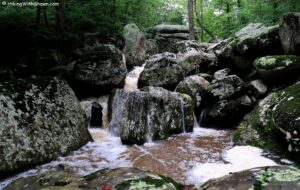
Hills Branch at Dixon Springs.
Hills Branch Creek (37°22’53.4″N 88°40’24.1″W) is located at Dixon Springs State Park. The coordinates listed will take you to an area (trail provided, creek crossing required) where when fairly wet, will be one of the coolest creeks you will ever see. This is a part of the Ghost Dance Canyon trail. The coordinates area is made up of huge boulders and rocks in the creek where water gushes out when we have had enough rain. If really wet, the area is very hard to get to and dangerous so please use caution. But if you can safely make it, something tells me that it will be one of your favorite creek spots to shoot photography. More Information
This sums up my 5 must visit scenic creeks around the Shawnee National Forest. Luckily, there are tons of creeks throughout the forest and even in our state parks. Many of these creeks feed awesome waterfalls too. You just have to get out there and explore. While exploring, please exercise safety and share the trails with others such as horseback riders which use a lot of the trail areas listed above. Thank you for checking out my article – remember to give it a share on social media.
One last thing!
Filming the videos, taking the photos, editing everything and writing this article takes time and it’s all provided for free. Consider making a small monthly contribution to Hiking with Shawn by becoming an official Patreon supporter on Hiking with Shawn! You can also support us by purchasing official merch from the Hiking with Shawn online store. Lastly, please share this article and our videos and follow us on YouTube, Facebook, Twitter, Instagram and Tumbler for more free guides, videos, photos, contests and more!
Thanks for checking out this guide and please share it with others if you’d like to see more of them made!
Shawn J. Gossman
Host
Shawn is the founder and host of the YouTube Channel, Hiking with Shawn as well as Hiking with Shawn LLC. Shawn hikes, backpacks and visits various forested areas in the Shawnee National Forest, local state parks and other areas promoting outdoor recreational activities to obtain video to show to locals and non-locals alike. Please support Shawn’s efforts by sharing this post and leaving a comment below.

Trackbacks/Pingbacks