Hiking with Shawn’s Trail Guide Series:
Schwegman Ecological Area
& Groundhog Den
Schwegman Ecological Area and Groundhog Den are unique gems in the Shawnee National Forest. I’ve talked to the fella who used to live in these areas before the land was sold to the US Forest Service to be made into the Shawnee National Forest. These two particular areas, right next to one and another are sort of hidden from public knowledge. Some people will not agree with me making this guide but it’s public land and everyone has the right to know about it, not just some.
However – please heed this plead: Schwegman EA and the Groundhog Den are precious areas. The Ecological Area was made an ecological area to protect some sort of rare plant species most likely. So it is strongly recommended that you tread lightly. These areas have no designated, maintained trails and there is private property around them. There are high bluffs, very rugged terrains and rocky slippery surfaces. These areas are not easy to hike in at all. I would never recommend this area as kid friendly, handicap accessible or for the beginner hiker crowd. This one is for the advanced folks!
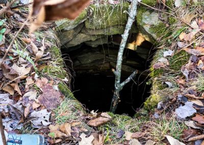
Warning: There are several unmarked, unprotected and open wells in this area. Falling into these very deep wells could mean death. Please always watch your step and never hike here at night. Camping is not allowed in these areas. Overnight parking would not be recommended at all.
Directions:
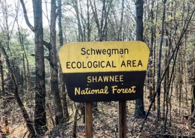
See this map created by some avid forest users. As you can see, the trail in uses a power line right-a-way. There are no parking spots other than on the side of the road. Do not block the road, your vehicle will likely be towed at your expense if you do. After parking, go SW in the right-a-way to reach the Groundhog Den area at 37.50991, -88.87742. Go SE from where you parked and follow the wood-line until you reach the EA sign for Schwegman. There is a faint old road (wide trail) that you can follow.
You really need a topo app on your phone to enjoy this area. I use OnXHunt (not sponsored) as it will show me topographic maps really well and private property boundaries as well as who owns the private tracts. Please don’t trespass.
Again, there are open wells out there. A few of them are in the power line right-a-way. They were marked by the electric company the last time I was out there (Nov 2020) but that ribbon may not be present when you visit. If the power line right-a-way isn’t mowed, expect it to be very difficult to get through and full of sticker bush briers.
What You’ll See!
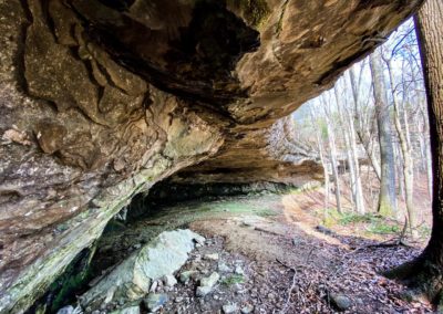
At Groundhog Den, you’ll start by going through a natural arch at the top of the bluff which takes you to the bottom of the bluff line. If it is very wet, there is a really nice waterfall there at the bottom. Follow this bluff life to the NW to see interesting rock formations, natural shelters stacked on top of one another and even signs of previous camping locations. This particular area isn’t a part of a natural area so camping could be permitted in a dispersed manner. Head back the other way to find your way up and back into the powerline right a-way or go back through the arch if you wish to.
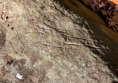
Schwegman EA is packed full of goodies. There are beautiful barren areas with some of the greenest moss, barren waterfalls and all kinds of patches of prickly pear cactus. Once you make your way into the canyon and follow the bluff lines, you’ll find mushroom-like rock formations, scenic creeks, extremely large natural shelters and interesting rock formations. By the larger cave shelter (horse cave), there are carvings present from previous owners of the land (non-Native American carvings). If you go when the area is really wet, you can expect several waterfalls around the canyon especially where two bluff lines will meet – another good reason to use a topo app to quickly find the waterfalls.
In the spring, seeing the wildflowers of the area and daffodils from previous settlements might be the reason to visit. Do note that in the warmer months, I have observed that venomous copperhead snakes occur in this area. I have also seen copperhead out of their dens during colder but sunny days of the cooler months as well. Again, another reason to watch your step.
Tips for the Trail!
- There are no trails and the terrain is very rugged. It will be a workout and sturdy shoes are required.
- Venomous copperhead snakes occur in this area, briers are all over, poison ivy is present and open unprotected wells are scattered around the area.
- This is a precious Ecological Area, please clean your boots and gear before entering to help stop the spread of invasive species that destroy natural species.
- Tread lightly and make sure you don’t step on anything that looks like a flower or plant if you can help it.
- Leave no trace – there are no trash services in this area. If you take it in, you should take it out. Be responsible.
- This is not an area for young kids or those who are new to hiking.
- I have not listed mileage since there are no trails. Too see everything, expect 7-9 miles of rugged hiking.
Watch the videos for this trail!
Below is a recent video that we filmed while enjoying this area.
One last thing!
Filming the videos, taking the photos, editing everything and writing this article takes time and it’s all provided for free. Consider making a small monthly contribution to Hiking with Shawn by becoming an official Patreon supporter on Hiking with Shawn! You can also support us by purchasing official merch from the Hiking with Shawn online store. Lastly, please share this article and our videos and follow us on YouTube, Facebook, Twitter, Instagram and Tumbler for more free guides, videos, photos, contests and more!
Thanks for checking out this guide and please share it with others if you’d like to see more of them made!
Shawn J. Gossman
Host
Shawn is the founder and host of the YouTube Channel, Hiking with Shawn as well as Hiking with Shawn LLC. Shawn hikes, backpacks and visits various forested areas in the Shawnee National Forest, local state parks and other areas promoting outdoor recreational activities to obtain video to show to locals and non-locals alike. Please support Shawn’s efforts by sharing this post and leaving a comment below.

